earthquake 4 September 2010 ...
sponsored by:
Sponsor Logo
space for lease

|
earthquake 4 September 2010 ... |
sponsored by: |
Sponsor Logo |
|
|
Christchurch September 4th a non-lethal, damaging 7.1 magnitude earthquake hit Christchurch area via 'new' Darfield hinterland fault. [Page under review edit.. N.B. this eastbound fault-extension EVENT THESIS has now been CONFIRMED]: New 22 February 2011 InfoHelp earthquake page; LandCheck.org.nz Canterbury Earthquake Recovery Authority CERA & In The Know "Answers to your questions about the rebuild and repair process in greater Canterbury" + Christchurch Central Development Unit CCDU + Canterbury Land Information - Reports Tonkin & Taylor esp EQC Geotechnical land reports Stage 3 land report July 2012 + Census 2013 Population shifts in Christchurch Press 15Oct13 New 13 June 2011 and 23 December 2011 InfoHelp earthquake pages 3 and 4. ChristchurchQuakeMap.co.nz time-lapse visualisation science Paul Nicholls + Dr Mark Quigley Lecturer in Active Tectonics Geomorphology Geological Sciences University of Canterbury & OCT. 20 EARTHQUAKE LECTURE mov ***** GNS Science article: Sep 10 2010 - Darfield earthquake damages Canterbury "Information so far suggests that the fault is pre-existing, and a patch has been reactivated during the Darfield earthquake. Large (up to 700 km long) normal faults with the same strike (direction) are numerous on the Chatham Rise, out to sea east of Banks Peninsula.. A preliminary estimate of the McQueen's Valley (MQZG) GPS receiver signals show displacement caused by the earthquake to be 135 mm at about 300 degrees azimuth. This permanent receiver is located on Banks Peninsula. This result is consistent with a magnitude 7.1 earthquake on a vertical strike-slip fault at the location where the geologists have found surface rupture, but it is only one point and it would be consistent with many other scenarios as well" & Darfield earthquake GNS response Christchurch Quake Live graphs maps quake.crowe.co.nz / Google maps for quake locations (input event coordinates) * Aftershocks have been steady, approx 2-hourly initially, magnitude 5.6 or less and on a textbook pattern of wane. #EQNZ Twitter Monitor "Live auto-refreshing feed of #eqnz tweets & Geonet quake updates.. to compare #eqnz tweets with incoming aftershock tweets" + Live Earthquakes Map globalincidentmap.com + Earthquakes @ Geoscience Australia 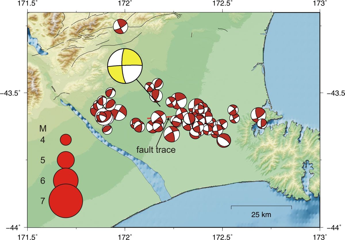 GNS graphics: "Focal mechanisms for the Darfield earthquake and some of its aftershocks", and see expansion below Multi-council Canterbury Earthquake.org.nz "Links to central & local government agencies & others supporting Canterbury people as they respond to the 4 September 2010 earthquake in Canterbury, New Zealand" news blog + Canterbury Earthquake.govt.nz "Links to central & local government agencies & others supporting the response to the Canterbury earthquake" + multi-agency Recover Canterbury "Practical advice & information to help your business recover from the Canterbury earthquake.. What does EQC cover?" + Canterbury Communities' Earthquake Recovery Network CanCERN "network of Residents Association and Community Group representatives from the earthquake-affected neighbourhoods of Canterbury" + Christchurch Earthquake Journal blog chcheqjournal.com etc + Assorted Goodies .blogspot.com "Images & Things from Zone City, Christchurch NZ" + Gap Filler "creative urban regeneration initiative started in response to the September 4, 2010 Canterbury earthquake" * * * * * ECan Canterbury Civil Defence Emergency Management Group CDEMCanterbury.govt.nz tragically politically side-lined Earth's surface 'lurches 11ft to the right' as New Zealand earthquake rips new fault line dailymail.co.uk 6Sep pix * * * * * Canterbury earthquake claims to cover new efficient heating "People whose chimneys have been damaged by the recent earthquake can choose to replace their old log burners or open fires with a new, efficient heating system and the cost will be covered under their claim to the Earthquake Commission (EQC)" Energy Efficiency and Conservation Authority EECA.govt.nz * * * * * + EarthquakeFIX.co.nz "use only competent and qualified tradespeople and contractors" & NoCowboys.co.nz "Kiwi tradespeople: find them, use them, rate them" + Let's Fix It "voluntary organisation set up for members of the plumbing industry to co-ordinate efforts to help the people of Christchurch get back on their feet by getting basic water and wastewater supply reconnected with no charge for labour, as soon as possible.. aiming for one toilet, one sink and one shower for each household" letsfixit.org.nz closed 030511 + Signs of coming large earthquakes survey documentation Dr Neil Whitehead chchquake.co.nz + Ideas for Christchurch "sharing architectural ideas for discussion" CPIT exhibition 30Sep10.. blog + share an idea "initiative developed by the Christchurch City Council.. to get the whole community involved in contributing their ideas and feedback for the future of our Central City following the earthquakes" + RebuildChristchurch.co.nz "non profit independent website provided to serve the residents of Christchurch suffering after both the September earthquake, the February quake and all the aftershocks between.. volunteers who are passionate to see Christchurch is rebuilt right.. website is run under the umbrella of the Rebuild Christchurch Foundation" links news etc Deon Swiggs + 'The day our house moved' blog 4 kids CTV news item ~16Sep Canterbury & Christchurch Earthquake Map "What's open & working? Info to help citizens & emergency service org's in the wake of Chch's earthquake" Google mapquake.co.nz "A rockslide from the east side of the Castle Rock buttress occurred during the initial 7.1 event. Rock and scree remains unstable in the vicinity of the release site. Huge boulders slid almost all the way to the tunnel road." - Port Hills, Banks Peninsula effects of major concern: NZ Alpine Club detailed Port Hills - Earthquake Update Sept 8th description of Castle Rock etc damage + Peter Taylor pix. 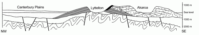 Banks Peninsula transect, graphic source: biblicalgeology.net/Geological-Histories/Banks-Peninsula-NZ.html VOLCANIC CONTEXT TO SEISMIC EVENT ~ Ruaumoko is awake in Earth crust fracture: could he be unleashed? NB see Seismograph Drum - McQueens Valley (MQZ) Canterbury NZ "image represents one day's recording of the seismometer located in McQueens Valley on Banks Peninsula" Fault awakens after 16,000 years of inactivity The Press 7Sep10 - or is that only 'invisibility' guesswork? NB 16,000 years ago was a time of dramatic global warming after an extended ice age!!! Earthquake Reports archive Sept 2010 context spinics.net Heathcote Valley - Castle Rock has been collapsing, then these shallow, very local events: New Zealand Earthquake Report Sep 8 2010 at 7:49 am (NZST) Magnitude 5.1 Wednesday, Focal Depth 6 km, Within 5 km of Lyttelton, 10 km south-east of Christchurch, 10 km north-west of Diamond Harbour" & Sep 8 2010 at 8:15 am (NZST) Magnitude 3.8 Wednesday, Focal Depth 5 km, Within 5 km of Lyttelton, 10 km south-east of Christchurch Heathcote Valley houses "jump" (NewsTalkZB) - Lyttelton road tunnel receives cracks, temporary closure, sulphur smells in tunnel and Lyttelton, fracture zone.. EVENT EXPERIENCED IN PORT HILLS AS A VIOLENT UPWARD SHOCK INTO ANCIENT VOLCANIC SUBSTRATE New Zealand Earthquake Report - Sep 8 2010 at 7:03 pm (NZST) Magnitude 2.6, Wednesday, Focal Depth 7 km, Within 5 km of Christchurch - Huntsbury Hill + 6:48 pm 2.8 mag 8 km under Summit Road More aftershocks loom as likely new fault jolts & $50m damage to Lyttelton port "Heathcote residents Sue Peers and Olivia Sanders were deciding whether to leave their house after further damage from the aftershocks. Peers said it had been much sharper in Heathcote than the first shake" & After the quake - what's working and what's not The Press 9Sept Somerfield and lower Cashmere have many chimneys down, but less effect is seen as one climbs the Cashmere Hills. And Mike Yardley reports no 4 Sept damage effect on Huntsbury Hill volcanic "bedrock buffer" NewsTalkZB 9Sept10 Reports of new sulphur/smell in East Christchurch (RadioNZ & NewsTalkZB) Christchurch Star says it's in old sand - too many "sand volcanoes" to ignore? in Halswell StAlbans Avonside Bexley Kaiapoi ... Reports of farmland flat fields "boiled up" into hummocks Darfield area Morning Report RadioNZ 9Sept10 + New Zealand Earthquake Report - Sep 9 2010 at 3:13 am (NZST) Magnitude 3.7 Thursday, Focal Depth 6 km, Within 5 km of Lyttelton, 10 km south-east of Christchurch - Ferrymead Historic Reserve 4.0 quake 5km deep under Halswell School which is wrecked by liquefaction and closed for "geothermal testing" (RadioNZ 10Sep10) near a second site of major excavation into volcanic bedrock (basalt quarry) fracturing? 3.4 quake 8km deep "20 km south-east of Hanmer Springs" thermal zone + 'war story' from Addington showground welfare centre council staff in Christchurch - a bore once sunk beside the road produced hot water so was unuseable. Lyttelton volcano revival discounted "Some people have even expressed fears the extinct Lyttelton volcano might be coming back to life. However, recent Canterbury University geology doctoral student Dr Sam Hampton said there was no evidence of volcanic activity. The Lyttelton volcanic complex finished erupting 5.8 million years ago. Hampton said he had discovered recent faulting at Allandale, where the road was cracked and the centreline had been offset by one to two centimetres. Also as a result of faulting, outflow from warm springs at the northern end of Rapaki Bay had increased. There were six sulphurous springs of up to 20 degrees Celsius within about 60 metres of the beach and oriented west-east, he said. 'The distinct sulphurous smell associated with these hot springs and other outflows is due to water coming up from depth, much like Hanmer Springs, and not to do with magma-water interactions'" The Press 11Sept + Underground water shaken up by fault "Some farmers say their paddocks have never been wetter. ECan acting director of investigations and monitoring, Tim Davie, said the quake could have a lasting impact, with some wells broken. No lasting large-scale changes were expected to aquifers. Sulphurous smells were being reported around the region but it was unlikely they were all related to new springs, he said. 'My view is it's some of the peat that's been exposed to air oxidising'" + new hotspring at Magazine Bay.. NZ Earthquake Report Sep 12 2010 at 5:03 am (NZST) Magnitude 2.6 Sunday, Focal Depth 2 km, 10 km north-east of Lyttelton, 10 km north of Diamond Harbour, 10 km east of Christchurch, Southshore Spit tip + Sep 12 2010 at 4:20 pm (NZST) Magnitude 3.1 Sunday, Latitude Longitude 43.59S 172.63E Focal Depth 6km, 10km south of Christchurch, west Cashmere Hills & Sep 13 2010 at 2:13 am (NZST) Magnitude 3.2 Monday 43.58S, 172.64E Focal Depth 7km, 10 km south of Christchurch, east Cashmere Hills + Sep 17 2010 at 4:53 am (NZST) 3.1 Port Hills Road + Sep 21 2010 at 9:51 am (NZST) Magnitude 3.3, Tuesday, 43.57S 172.73E Focal Depth 2km Within 5 km of Lyttelton, 10 km south-east of Christchurch - Moncks Spur + ... Oct 13 2010 at 9:11 am (NZDT)Magnitude 3.2, Wednesday, 43.57S 172.63E Focal Depth 5km Within 5km of Christchurch, Valley Rd Cashmere Hills + 16Oct10 4:56:55AM Magnitude 2.59 Depth 4.75 km Huntsbury + 17-Oct10 7:20:50PM Magnitude 3.56 Depth 5km Near 367-385 Dyers Pass Rd, Cashmere Hills + 19Oct10 3:19:20AM Magnitude 2.81 Depth 9.29km Governors Bay Rd, Rapaki + 19Oct10 11:32:15AM Magnitude 5.02 Depth 8.92 km Old Tai Tapu Rd, Lansdowne ('7' felt in Chch city, shut down airport, Lyttelton road tunnel, & Cashmere water supply until ~7pm) + ... + 19Oct10 11:41:13AM Magnitude 3.73 Depth 5km Near Pigeon Bay + 19Oct10 12:06:12PM Magnitude 3.38 Depth 3km Quaifes Rd, Westlake + 19Oct10 2:22:44PM Magnitude 3.26 Depth 8.38km Cashmere Rd, Hoon Hay + 28Oct10 07:12am Magnitude 2.46 Depth 10.95 km Near Rapaki + 06Nov10 05:37am Magnitude 3.10 Depth 5.13 km Kidson Tce Cashmere ... + 7Dec10 11:49pm Magnitude 2.56 Depth 5.00km 110 Shalamar Dr, Cashmere + 15Dec10 11:03am Magnitude 3.24 Depth 5.86km Near 250 Huntsbury Ave Cashmere ... 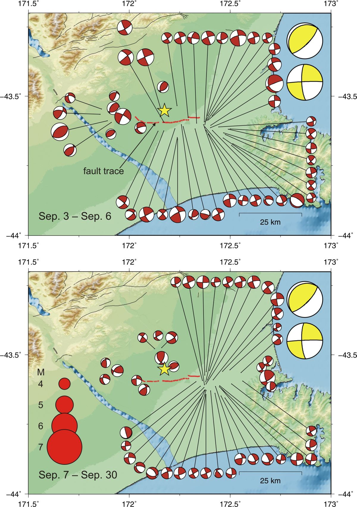
 Greendale Fault trace expanded & NZ legend map, graphic sources: GeoNet & biblicalgeology.net Banks-Peninsula-NZ 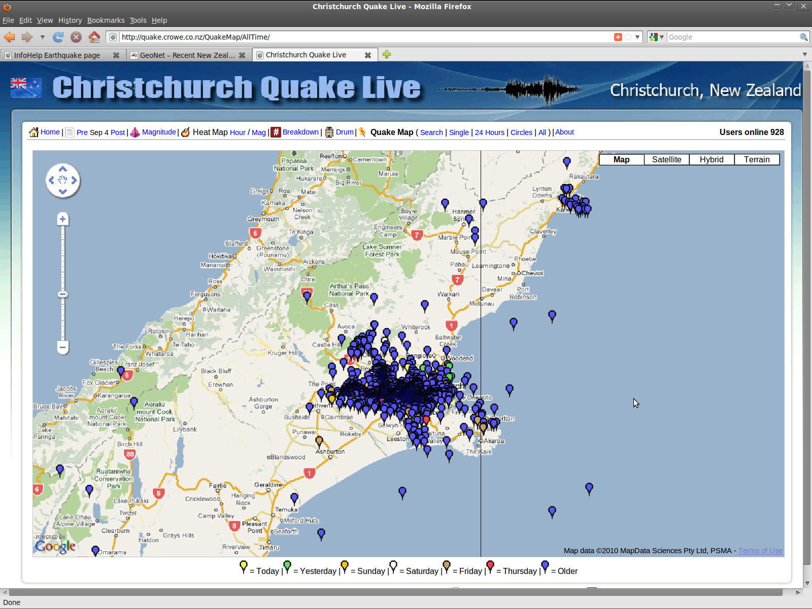 Overview of Canterbury Sept-2010 shallow earthquake sequence, Christchurch, Kaikoura & Southern Alps, source: Crowe.co.nz Christchurch Quake Live All Wider New Zealand GeoNet.org.nz GNS Science Te Puu Ao "NZ's leading provider of Earth, geoscience & isotope research & consultancy services" max tech /Earthquake/Resources "earthquake-related data resources & tools" & /Volcano Current Activity ***** Ministry of Civil Defence & Emergency Management MCDEM 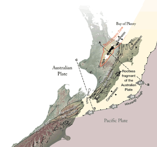  New Zealand's Fault Lines "Stresses in the crust along New Zealand's plate boundary have broken it into separate fragments or blocks that move relative to each other along fault lines.. A fragment of the Australian Plate east of the more stable part of the Australian Plate is separated from it by the Marlborough and North Island fault systems. This eastern fragment rests directly on the Pacific Plate, which is subducting obliquely beneath the Australian Plate" source: gns.cri.nz; + Geonet recent quakes 4 Oct 2010, highlights the 200km-deep active Pacific Plate subduction front, source of volcanic magma and another obvious 'long straight line' 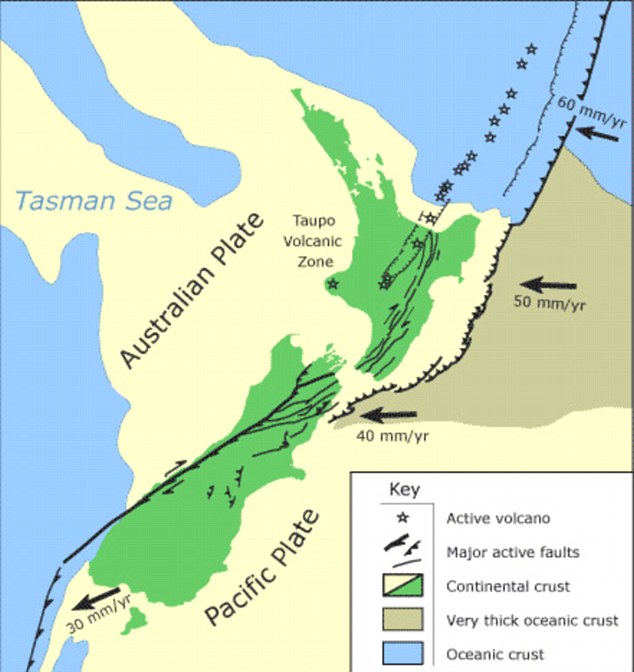  PlanetWare.com graphic source: dailymail.co.uk World 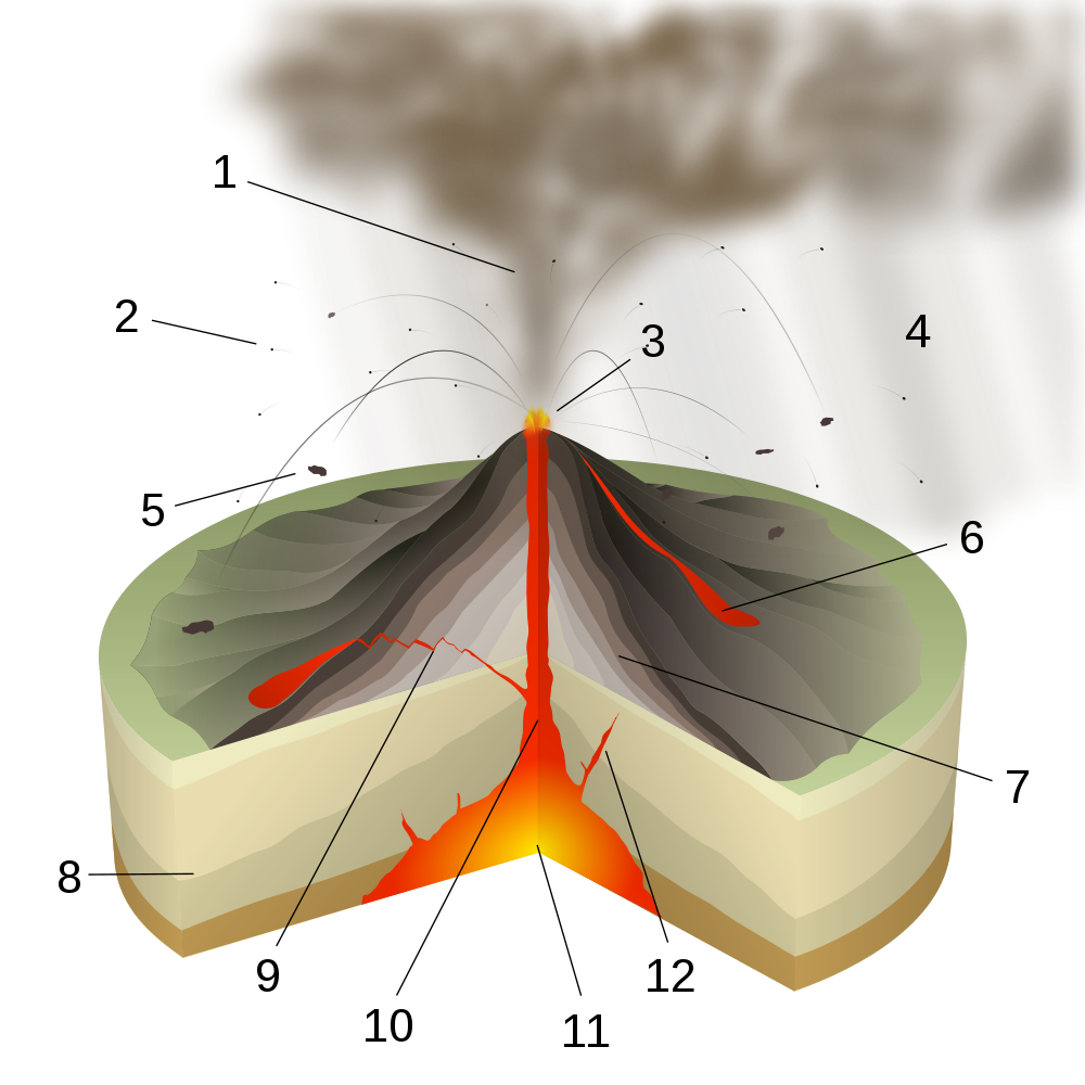 An active magma chamber under central Canterbury? - Not for five to six million years past. An active magma chamber under central Canterbury? - Not for five to six million years past.Magma_chamber "large underground pool of molten rock found beneath the surface of the Earth.. under great pressure, and given enough time, that pressure can gradually fracture the rock around it creating outlets for the magma. If it finds a way to the surface, then the result will be a volcanic eruption; consequently many volcanoes are situated over magma chambers.. hard to detect, and most of the known ones are therefore close to the surface of the Earth, commonly between 1 km and 10 km under the surface. In geological terms this is extremely close to the surface, although in human terms it is considerably deep underground. Magma rises through fractures from beneath the crust because it is less dense than the surrounding rock. When the magma cannot find a path upwards it pools into a magma chamber. As more magma rises up below it, the pressure in the chamber grows" Wikipedia Magma & East Australia hotspot & Hotspot (geology) + Volcano Safety Warning Signs ehow.com/facts + New Magma Layer Found Deep in Earth's Mantle? nationalgeographic.com/news ... etc Any new magma chamber local to the South Island would probably appear south of this Pacific Plate land mass, where its subductive force is not restrained by the Australian plate at the Southern Alps - west of Foveuax Strait, behind the deep quake Fjordland front. It is the magma chambers more active around the North Island, under Australian Plate subductive force, that present true killer risk. (See Pushing New Zealand's Boundaries) Climate change linked to quakes "Climate change doesn't just affect the atmosphere and the oceans but the Earth's crust as well. The whole Earth is an interactive system" The Press 29Sep10 Dinosaur origins pushed further back in time "The first dinosaur-like creatures emerged up to nine million years earlier than previously thought.. conclusion of a study on footprints found in 250 million-year-old rocks from Poland.. Prorotodactylus.. prints are small.. a few centimetres in length.. about the size of domestic cats.. at most a kilogram or two.. walked on four legs.. very rare animals.. The footprints date to just two million years after the end-Permian mass extinction - the worst mass extinction in the history of the planet.. more than 90% of all life on Earth was wiped out due to massive volcanic eruptions, sudden global warming and the stagnation of the oceans.. scientists had thought that dinosaurs emerged 15 to 20 million years after the mass extinction, when the planet had become more habitable. But the new footprints suggest that the rise of dinosaurs was intimately related to the devastating extinction event" BBC.co.uk News 5Oct10 & Dinosaurs' dominance 'helped by mass volcanism' "volcanic eruptions changed the climate, causing a mass extinction that wiped out the dinosaurs' main competitors.. lava flows are dated to the end-Triassic extinction, 201.4 million years ago, which wiped out 50% of tetrapods (four-limbed animals) on land, 50% of terrestrial plants and 20% of marine families.. 'flood basalts' form a giant geological entity known as the Central Atlantic Magmatic Province (Camp). This was formed during the break up of the 'supercontinent' known as Pangaea, causing lava to pour out on to the Earth's surface for some 700,000 years.. extinction of the dinosaurs 65 million years ago. a space impact was instead responsible.. a 10-15km space rock striking the Yucatan Peninsula.. caused a global winter that played havoc with marine and land ecosystems" 23Mar10 RingLaser.org.nz research group "development of world-leading active ring laser gyroscopes for measuring subtle variations in the rotation rate of the earth" Cashmere Cavern Lab, University of Canterbury Physics & Astronomy Dept Big parts in the global solution: SolventRescue.co.nz "liquid fuel production from algae.. the most common available organic matter is woody cellulosic material. This is the major component of most trees, shrubs, and grasses. Solvent Rescue has the ability and plant to make extractions at high pressure and temperature" Sydenham + LignoTech.co.nz "Manufacturing bio-composite plastics from sustainable renewable resource materials.. up to 80% of virgin plastic can be replaced by LignoTech material with no modification to standard injection molding equipment.. modified biomass can replace a high percentage of expensive petrochemical plastics in certain applications, leading to reduced costs and improved margins" Ashburton Another 'straight line' too obvious to ignore.. North New Brighton fault extended & getting shallower, 24Oct10 graphic source: quake.crowe.co.nz Quake Map: 03:13PM Mag 4.78 Depth 9.33km Near Waimairi Beach + see column right 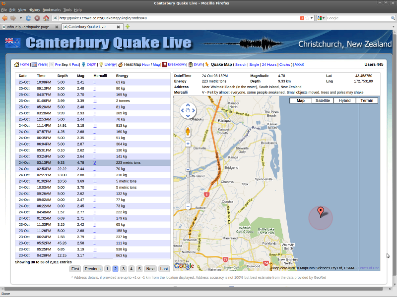 North New Brighton fault line traced below, by magnitude 4.x quake points Sep-Dec 2010: 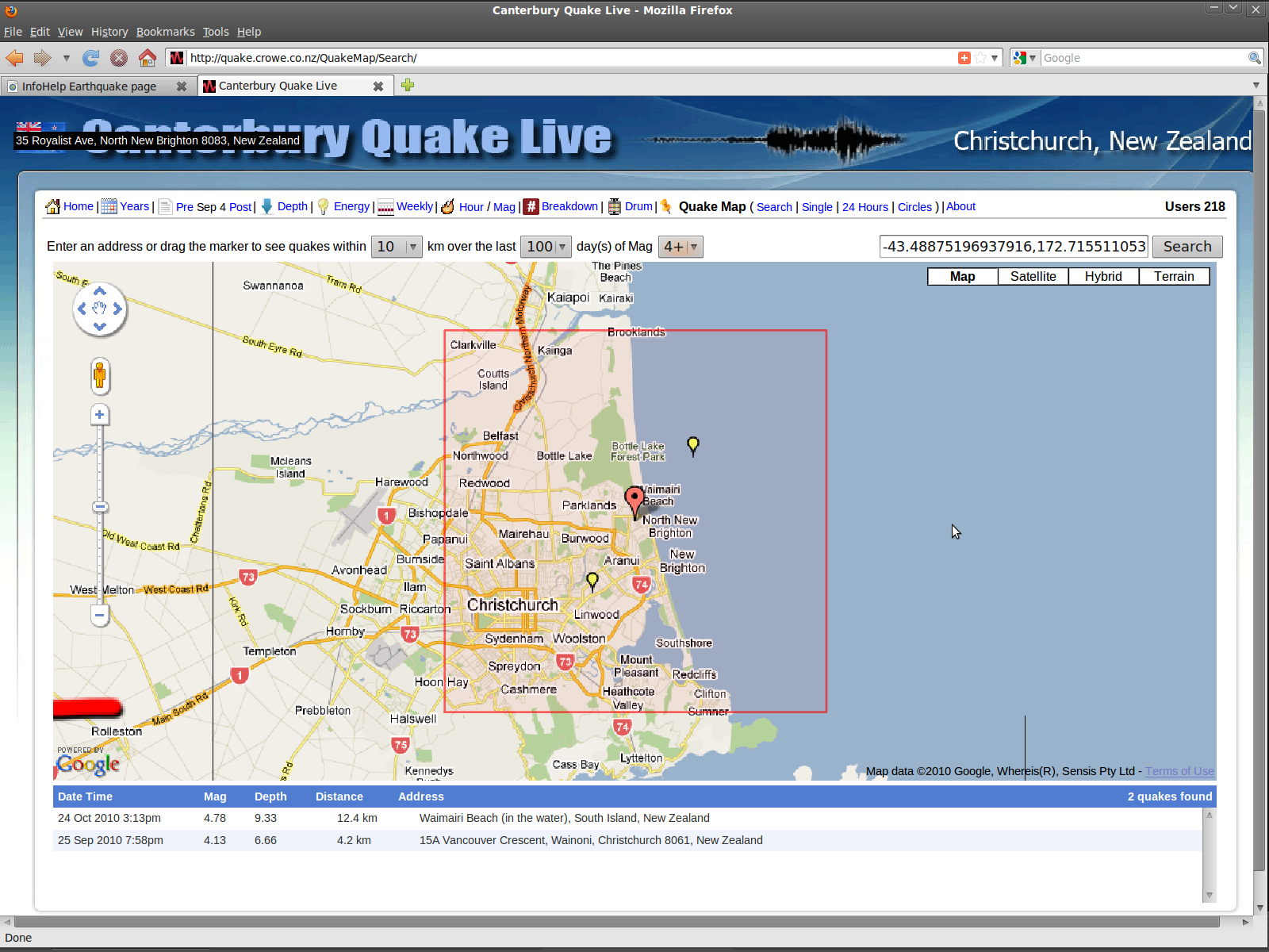 North New Brighton fault line traced below, by magnitude 3+ quake points Sep-Dec 2010: 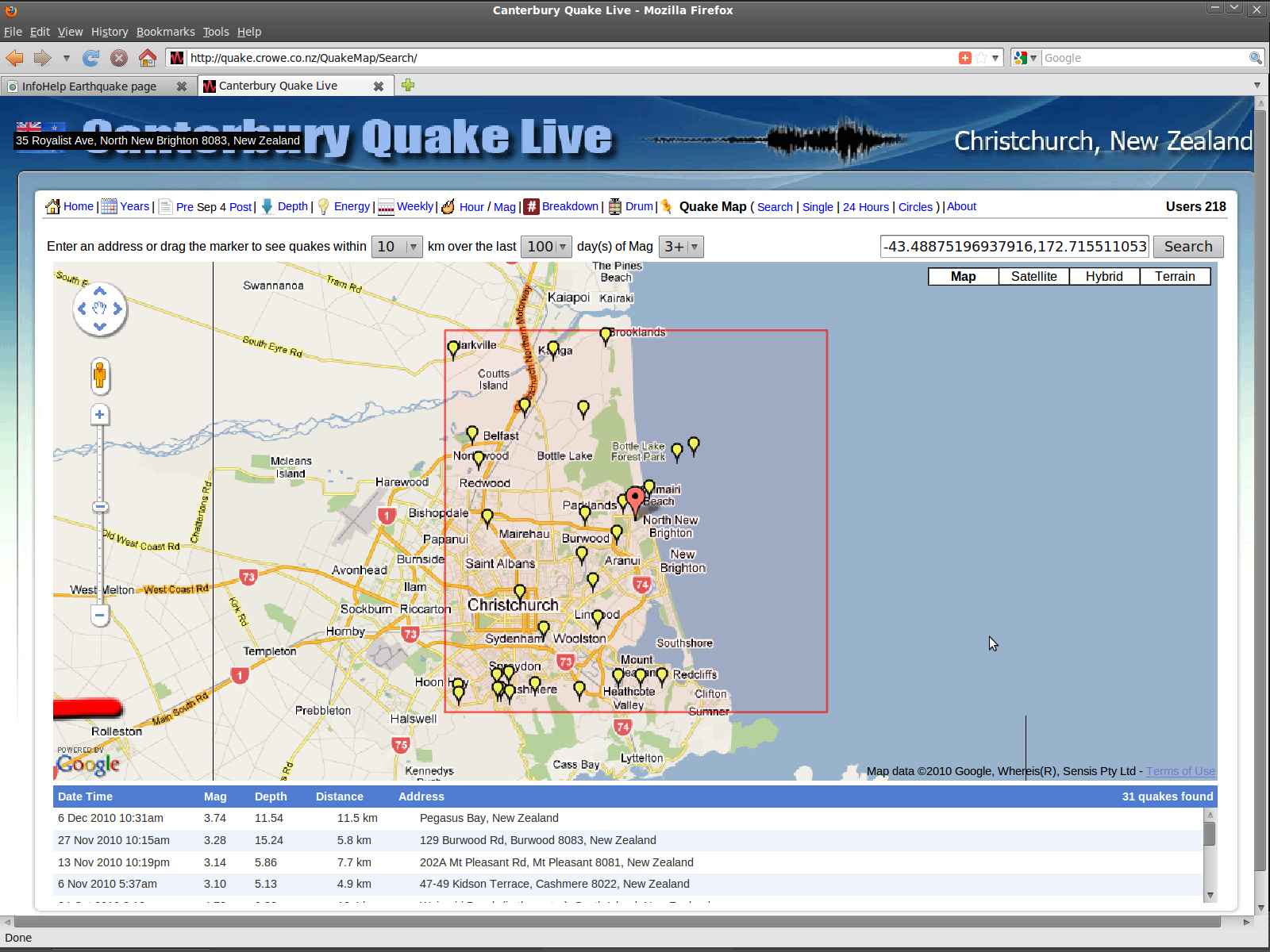 The Sep-Dec 2010 3+ quake trace highlights three significant things: 1 The Greendale Fault (horizontal red line at bottom left) seems to be extending further east, through the northern base of Banks Peninsula at lower Port Hills; 2 The North New Brighton fault spiders / fractures north-east off the Greendale Fault, from Hoon Hay through Spreydon, Sydenham, City, Linwood, Aranui and Burwood, and off out seaward thence; 3 Government "experts" remain dumb regarding this. Then Boxing Day Quake directly beneath Christchurch "Their shallowness and location below Christchurch and out towards the Port Hills indicated a link to the magnitude 5.1 quake near Heathcote on September 8, which had also caused alarm and damage. Scientists have speculated over whether the recently revealed Greendale Fault continues east underneath the city" Press 27Dec10 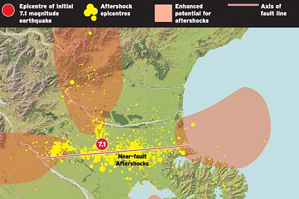 Graphic source: Aftershocks 'exactly what we expected' The Press 25Jan11 Whose fault is it anyway? The scientists remain divided GNS Science: "There are earthquakes under Christchurch which could be interpreted as an extension of the Greendale Fault.. wouldn't necessarily want to draw a straight line through the city, but with Boxing Day and [Tuesday morning], we are looking to replot things" The Press 27Jan11 Alpine Fault unlikely to trigger Port Hills rockfall "the last time substantial numbers of rocks fell around Rapaki was about 7000 years ago.. it's only really near-fault earthquakes that actually cause rockfall" The Press 3Oct14 Wellington's fault find prompts grim warning "A previously unknown fault zone with the potential to severely damage New Zealand's capital has prompted fresh calls for vigilance.. The Aotea Fault has lain beneath Wellington Harbour giving no hint of the havoc it could unleash every few thousand years.. 'Ultimately, the first response isn't the ambulance, emergency services and all that, the first response is your neighbours'.. newly-found fault was capable of producing a shake of up to magnitude 6.3 to 7.1. But how often it ruptured could only be narrowed down to every 'several thousand' years. The last big shake scientists could spot in its geological record was 6200 years ago." The Press 9Oct14 Groundwater changes may warn of big quakes "certain chemical signals rapidly increased in underground water weeks before large earthquakes hit Iceland.. stress building up along the fault-line before a quake pulled and distorted the rock, exposing new surfaces to the groundwater. Previously untouched rock would then leach its calcium, sodium and silicon into the water, giving the signature spikes" The Press 18Oct14 Megaquake could hit central New Zealand "in the past 1000 years two subduction quakes of at least magnitude 7 occurred - one between about 880 to 800 years ago and the other between 520 and 470 years ago" stuff 19May15 & Chat recap: Scientist Kate Clark on 'mega earthquakes' "There is no way of accurately predicting future subduction earthquakes although new methods are always developing and some subduction earthquakes do have foreshocks which is an active area of research" Dominion Post Geologists inch closer to understanding Mt Taranaki's mysteries "unusual earthquakes that occur in an East to West line from Ruapehu to Mt Taranaki" Stuff 17Feb17 & Massey researchers' new discovery helps plan for volcanic disasters in Taranaki "'Many of us believe that Taranaki is well overdue for an eruption,.. But there are no current signs of any magma movements.' Mt Taranaki is a rarity in the world of volcanos as its last five eruptions have been cone collapses, where the peak of the volcano falls inwards after an eruption" 13Sep16 + Mt Taranaki volcano history revised "latest eruption [tentatively called the Pyramid eruption].. any time up to around AD1800" Taranaki Daily News 11Oct11 |
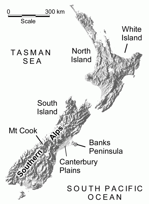
A 'long straight line' too obvious to ignore? (event analysis) Note the horizontal shape to the Canterbury earthquake swarm map. Could this be the westward drift tip of an ancient terra-forming magma source, on the expanding Pacific plate, seeking new vent? If so, the scenario here would be similar to Pompeii, 79AD. So let us understand this "vertical strike-slip fault", with full rational science, for safety's sake.. We live aside an historically ~ though long extinct ~ isolated old volcanic zone.[1] This webpage explores any risk of resumed catastrophic volcanics: discounted for Canterbury, but very real in the central North Island of New Zealand. And very real in Christchurch, the potential for a local (non-Alpine) magnitude 8.1+ quake - a characteristic extension on the Chatham Rise geological feature (the long-ceased local Pacific Plate subduction front laying roughly perpendicular to its current Alpine expression) of a 260km+ long fault (520km = magnitude 8.2, 780km = 8.3 ..) - has just been revealed: should the Greendale Fault revive further to extend itself east towards the Chatham Islands. "Geologists believe that if a fault.. has moved at least once in the past 5000 years, then it should be considered a potential source of damaging earthquakes to any settlement within a radius of 50km. Once a major fault has formed, future earthquakes are generated along the same line" Active Faults GeoNet. All NZ should be on QUIET ALERT.* [1] Before going out and finding the best moving companies, calling any moving companies or searching online for any moving companies consider the information on this page. NB Lyttelton eruption 'not possible' "Some of the country's top earthquake and volcano experts are now determined to quash the gossip before it scares even more people" The Press 23Jun11. InfoHelp fully supports this risk assessment, and says: "Geo-historically, you can have the Southern Alps as a long transform fault, or you can have an active volcano nearby - you cannot have both. The tectonic plate collision, started very long ago that built up the Southern Alps, stalled and extinguished Banks Peninsula volcanos early in the process"; see Pushing New Zealand's Boundaries GNS Science 65-million-year land formation simulation. - Not here, a Yellowstone Supervolcano Much Bigger Than Thought News.discovery.com 23Apr15 But there, is a 'Supervolcano' forming near New Zealand Tonga Trench area Stuff 13Feb13 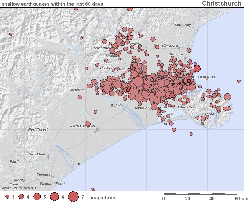 Christchurch latitudinal rift, graphic source: GeoNet The Press cites lead geologist Kelvin Berryman: '..the longer the fault, the larger the quake magnitude potential. The Southern Alps fault, at 400km length but at greater distance to Christchurch than the new Greendale Fault, can produce a magnitude 8 to 9 quake of a similar felt intensity in the city' - "the Darfield earthquake was a magnitude 7, because the underground rift that moved, that slipped by a further three metres along its length, was about 25km long. To get a magnitude 8 quake, one 10 times more violent, you would need to have a fault line 10 times longer. This is why the Alpine fault, which can slip by about eight metres along a segment some 400km long, is the only possible source of an 8-plus "big one" in the South Island. It is also why geologists are not too bothered by the maze of smaller cracks that lie everywhere beneath the surface of New Zealand. A fault line about 5km long can generate only a magnitude-6 disturbance, a half-kilometre crack can produce only a 5, and a fissure of a few hundred metres will only ever give a 4" [What lies beneath? Mainlander 18Sep10] & "Scientists say Canterbury's Greendale Fault has grown another 4km and is now 26km long" etc + Fault changes may be good for Canty "Different types of ground motion had been experienced around the Hororata Fault and the previously hidden Rolleston Fault.. 'The people around this area felt themselves thrust straight up into the air. The first we felt in Christchurch was from side-to-side.' Strain on faults around the region had been relieved as as result" 15Sep10 + Scientists can't rule out fault below Chch 6Oct10 & Liquefaction study too late for worst-hit areas & New fault seen as earthquake trigger "evidence points to a blind thrust fault [1] lying at depth somewhere in a broad northeast to southwest zone centred on the focus of the big quake close to Charing Cross.. Seismologist Bill Fry said there was still a lot that was unknown about the second hidden fault. 'The Greendale Fault extends down through the upper and middle crust to about 10 to 12 kilometres. But the thrust fault - we're still deciding on the exact location of that.' The large quake changed the strain levels in rocks around the region, he said. 'This has created an increase in stress fields in some areas and a decrease in others.' Fry said the areas with the greatest strain were where the aftershocks were located" 14Oct10 & More big jolts ... maybe "shortfall in the amount of energy released by the continuing Canterbury shakes. The total energy released in magnitude 4.0 or more aftershocks over the first 18 days in the [7.1] Haiti quake was about 245 trillion joules, while the amount in magnitude-4.0 Canterbury aftershocks since September 4 had been only 85 trillion joules" 16Oct10 = Alpine stress loading instead? ... & Engineer favours piles over concrete slabs vs Liquefaction etc 18Oct10 & Thirst for quake info at lecture "presentation by geological sciences lecturer Mark Quigley..September 4 quake was unlikely to have substantially affected the 650-kilometre-long Alpine Fault.. It had not been triggered by several other sizeable quakes in the past century.. the Canterbury quake was likely to have involved the rupture of an entire fault" 21Oct10 & Scientists find four faults caused shake "a lot of energy from the original two ruptures was going into Banks Peninsula and reflected back up into Christchurch" etc 29Nov10 + ground deformation Satellite radar results gns.cri.nz 2Dec10 + Scientists Set To Probe Alpine Fault "20% chance of a big quake on the fault in the next 20 years.. last ruptured 290 years ago and moved the ground 27m horizontally along 300km.. new clues about what happens in the lead-up to a major quake about 10 times as powerful as the Canterbury's 7.1-magnitude quake on September 4.. ruptures every 200 to 400 years -- producing earthquakes of about magnitude 8 -- most recently in 1717 along nearly 400km of the southern two thirds of the fault" NZPA voxy.co.nz 5Jan11 + Alpine Fault dams water to east, study finds 100m & 151m bore holes show "waterproof seal between two of the world's major crustal plates.. project at Gaunt Creek has attracted more than 20 researchers and engineers from around the world. The Alpine Fault runs more than 450km from Marlborough down the western edge of the Alps and offshore at the entrance to Milford Sound. Researchers believe the fault ruptures every 300 or so years and last moved in 1717. It is expected to generate a magnitude-8 earthquake when it next yields to pressure from the Australian and Pacific plates.." The Press 9Feb11 [1] Blind thrust earthquake "usually of magnitude 6 to 7.. especially destructive because the seismic waves are highly directed.. contribute more to urban seismic risk than the 'big ones' of magnitude 8 or more.. 'the tectonic squeezing across Los Angeles will likely produce earthquakes on either the blind Elysian Park or Puente Hills thrust fault systems. Large regions of metropolitan Los Angeles were rising and falling by up to 11 cm per year, but this was largely due to pumping and recharging of groundwater" Wikipedia + An Elusive Blind-Thrust Fault Beneath Metropolitan Los Angeles Science Mar99 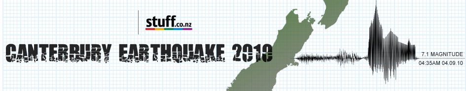 The Press earthquake event graphic - approximately traces the theoretical latitudinal rift line, east to the Chathams Tracing the historic route of this "extinct" magma chamber to its eastward origins, is the Chatham Rise as found on the Zealandia Continent map. Above water, currently, are only Rekohu / the Chatham Islands to the east, and Horomaka / Banks Peninsula in the west. Will there be a next phase to this terra-forming engine, in the next age of Earth vulcanism?.. 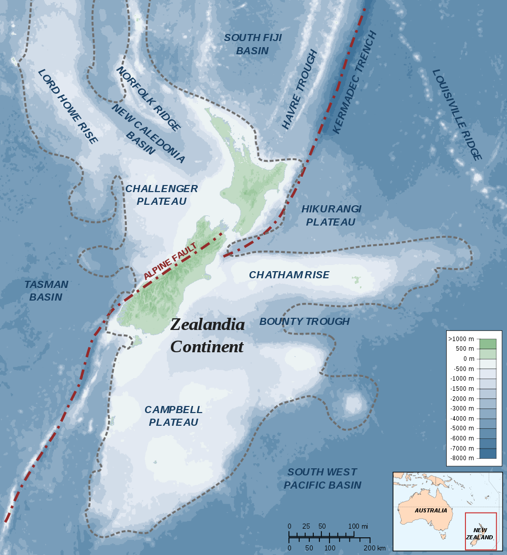 Zealandia Continent map, graphic source: Wikipedia. Better, see NIWA bathymetry & news Tortion from 2008-2009's many Fijordland quakes, that shifted Dunedin 30 centimetres west on 15 July 2009 alone, is tensioning the Alps and Canterbury towards The Big One here in time. For now, like an enormous liquid iron gong, the soundings forth from the Canterbury former magma zone have a mirror image echo, similarly big and regular, beneath current Porangahau events at Hawkes Bay and 200 km beneath Tokoroa. The explanation of the 2010 Canterbury quake is this: The Pacific plate is on the move, probably accelerated by global warming. It is pivoting New Zealand east to west in the south, around the Cook Straight axis, with the Australian plate doing the same west to east in the north. The scale of movement is most great at the extremities - Southland and Northland - so the different pace of turn per latitude causes earth fault slippage for releasing the twist force. ( See TeAra.govt.nz geological-exploration Australian/Pacific plate techtonic simulation + Pushing New Zealand's Boundaries land formation simulation GNS youtube from The History of Zealandia + NZ 4M-year deformation.mov projection * * * * * ) The Canterbury earthquake phase begun on 4 September 2010 is a stress energy release very typical of the Chatham Rise geological feature extending far to its east. The twisting of the southern South Island - west against its plate impact crumple compression spine (longitudinal Alps) - is what tensions the more porous and brittle Chatham Rise volcanic land mass (extending centrally and latitudinally east) and causes this family of earthquake faults. The energy is transferred by these latitudinal strikes, northwards from here, into north Canterbury and on to the Hikurangi Trough. Ref. Major slip near Kaikoura closes State Highway 1 until next week "The possibility that the slip was caused by earthquakes is not being ruled out" NZTA + SH1, railway near Kaikoura closed until Thursday at best "Heavy rainfall, and not recent earthquake activity, is being blamed for the slip" The Press 12Sept + Sep 15 2010 at 4:15 pm (NZST) Magnitude 3.5, Wednesday, 42.49S 173.82E Focal Depth 5 km, 10 km south-east of Kaikoura, 60 km north-east of Cheviot, 110 km south of Blenheim, 150 km north-east of Christchurch + Sep 15 2010 at 5:01 pm (NZST) Magnitude 4.2, Wednesday, 42.47S 173.75E Focal Depth 11 km, 10 km south-east of Kaikoura, 50 km north-east of Cheviot, 110 km south of Blenheim, 150 km north-east of Christchurch + Sep 15 2010 at 5:38 pm (NZST) Magnitude 4.2, Wednesday, 42.49S 173.76E Focal Depth 10 km, same locale + combination of rain and earthquake confirmed as slip cause RadioNZ News 16Sep10 + 20Oct10 3:15:32AM Magnitude 2.78 Depth 21.47km northeast of Kaikoura The risk of imminent Alpine fault-slip is very real, given the clear evidence of recent full-length lateral pressure upon it: 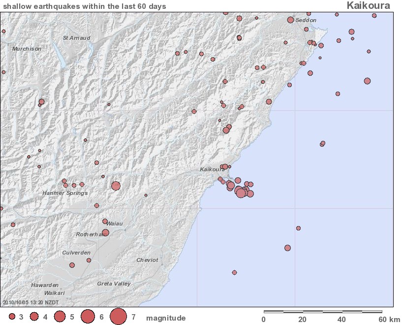 Kaikoura latitudinal rift, north of and parallel to Christchurch's and the Hikurangi plate boundary, graphic source: GeoNet In the battle of the Australian and Pacific plates, to the north the Australian Plate is victor by subduction that drives Taupo zone volcanics with variable force over time / temperature conditions. In the south, the Pacific Plate is victor and holds the Australian Plate back by Alp-forming scrum, so its volcanics - Banks Peninsula and Port Chalmers - are permanently extinct. The Australian land mass could warm more significantly and succeed in pushing harder back, but subduction is unlikely to result that would sink Canterbury and generate new volcanoes west of the Alps. Assuming the Australian Plate loses its age-old wrestle with the Pacific Plate, and observing the macro-process that formed the Chatham Rise over aeons of volcanic resurrection to make a giant westward ridge, then this 'new' rift could potentially be a preceding tear in the Earth's fabric that ushers in a new local age of heated, magmatic land formation. That is, the ancient Chatham Rise subduction ridge has always built itself forward volcanically. perhaps in this 'split and release' way, at plate contact point. So will this 'new' land mass fracture bisect the Alps, or push them aside and to the north, to continue moving forward and west? ... 'No movement imminent on the Alpine fault soon' (What lies beneath? The Press 18Sep10) - So what is this then?: 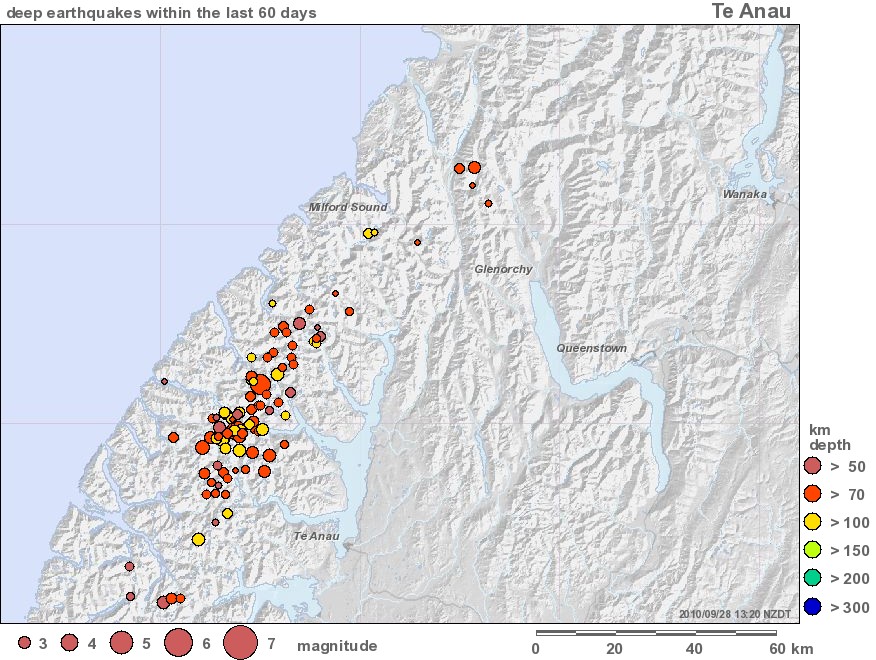 Southern Alpine longitudinal rift, graphic source: GeoNet Note  Sept-Oct 2010 northern subduction fault quakes, undersea B & D felt in Christchurch, graphic source: Google maps  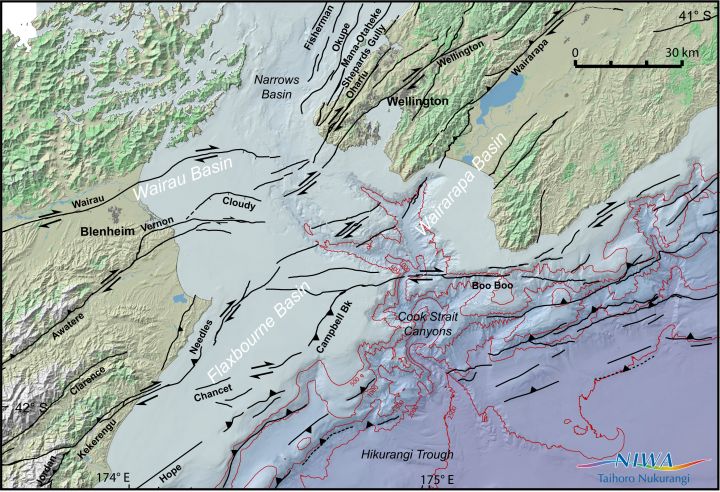 NZ TECTONIC ACTIVITY IS UP this spring!.., graphic sources: Geonet recent quakes 13 Oct 2010 & NIWA: "Meanwhile, National Institute of Water and Atmospheric Research scientists are developing ways to interpret the history of undersea earthquakes occurring on major marine faults around New Zealand. Principal scientist Phil Barnes said the focus had been on three Marlborough faults - Wairau, Cloudy and Vernon - that ran into Cook Strait. 'We have found eight prehistoric earthquakes on the Wairau Fault of more than magnitude 7.0, six on the Cloudy Fault and five on the Vernon Fault, which have all been big earthquakes in the past 18,000 years,' he said" New fault seen as earthquake trigger The Press 14Oct10 + NIWA finds new ways of seeing past earthquakes - under the sea NIWA.co.nz "The Wairau Fault, which is the northern part of the Alpine Fault.. Dr Barnes says, 'If you know a fault has an earthquake on it every two thousand years on average, and it's been close to that elapsed time since the last one, then it could be reasonable to interpret that it is due for another one.'" 13Oct10 + radionz news 'Wairau Fault quakes every ~2200 years, the last one being 2000 years ago' = Seismic studies shed light on natural disaster risk "Scientists are looking beneath their feet, the sea, even the south stand at Eden Park to increase their knowledge about volcanic eruptions and earthquakes" radionz 13Oct10 mp3 = 'magma rises quickly and imperceptibly from 80-100km depth, whence earthquake clusters become vague sign from brittle crust breaks @30km days or weeks ahead' & Auckland more vulnerable to volcanic ash-fall than thought "Scientists have discovered that Auckland has been hit by twice as many volcanic eruptions than previously thought" Dr Jill Jolly GNS Science '20-30,000 years ago Auckland area outbursts & Rangitoto 550 years ago or outbursts every 2,500 years or every 200 years' + Auckland virtual Eruption "As the volcanic hot spot beneath the city begins to stir, Auckland faces a massive natural disaster.. Get Ready Week 2010" ondemand.TV3 13Oct10 = ominous prep? + NIWA confirms collapse of undersea volcano "'Rumble III' undersea volcano on the Kermadec Ridge, 200 km northeast of Auckland, has dropped in height by 120 metres in the last couple of years, pioneering research by NIWA has shown. 'Our seabed is a lot more active than we thought,' says NIWA marine geologist, Richard Wysoczanski. 'Within the last ten years there have been numerous undersea volcanic eruptions and activity: Monowai (several times up to 2008), Raoul Volcano (2006), and White Island (2000 and 2001)'" 16Aug10 35.745S 178.478E & Rumble III @volcano.si.edu Smithsonian's Global Volcanism Program = sign of Great Change afoot?.. 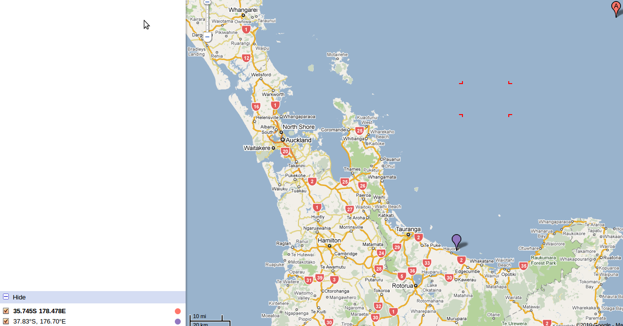 A = Rumble III, & 071010 magnitude 2.7 Matata quake location, graphic source: Google maps Reference: 3405546 NZDT: Thu, Nov 11 2010 4:25 pm Magnitude: 2.4 Depth: 1 km Details: 10 km north of Taupo Reference: 3405612 NZDT: Thu, Nov 11 2010 1:51 pm Magnitude: 2.4 Depth: 1 km Details: 10 km north of Taupo Reference: 3405479 NZDT: Thu, Nov 11 2010 1:45 pm Magnitude: 2.2 Depth: 1 km Details: 10 km north of Taupo Reference: 3405425 NZDT: Thu, Nov 11 2010 11:38 am Magnitude: 1.7 Depth: 2 km Details: 10 km north of Taupo ; Geonet recent quakes Clark Volcano "130 km NE of White Island" volcanolive.com + Mapping Volcanoes julians blog GNS 3Mar11 North New Brighton fault revealed 04Oct10 4:03pm mag 3.13 Depth 12km + 4:17pm mag 3.48 Depth 12km 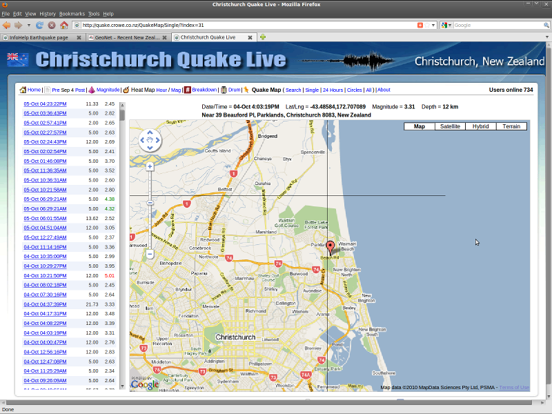 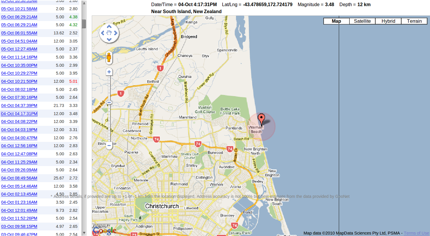 Graphic source: quake.crowe.co.nz Quake Map For detail, "View image" & enlarge + 24-Oct 03:13PM Magnitude 4.78 Energy 223 metric tons Depth 9.33 km Near Waimairi Beach, see column left 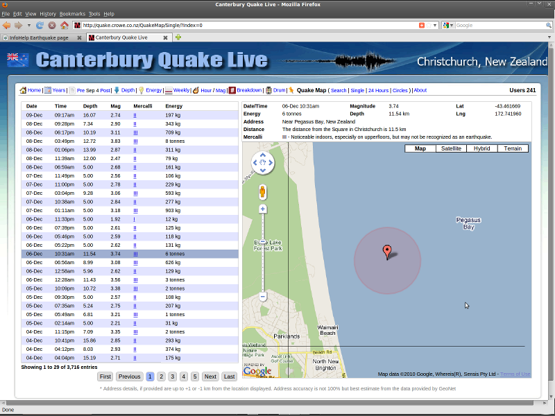 + yet another New Brighton fault quake, 06Dec10 Magnitude 3.74 Depth 11.54km 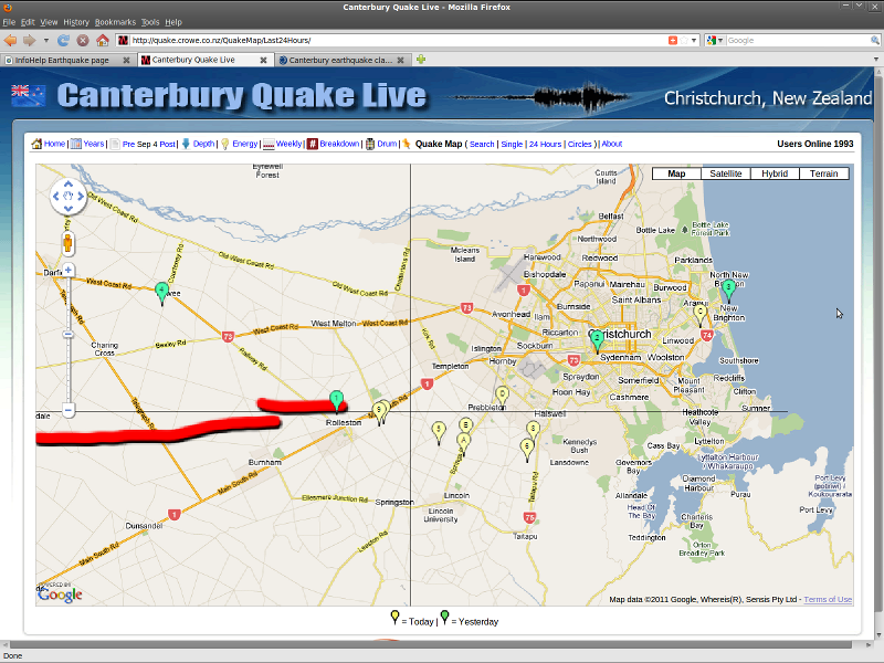 New Brighton fault dramatically confirmed in crowe.co.nz/QuakeMap/Last24Hours 20Jan11 Conclusions - N.B. The main conclusions from this first - 'start at knowledge/event ground-zero' - page of earthquake analysis are threefold: 1. Complete, researched elimination of active volcanics as the earthquake cause (see material both columns above); 2. Trace of seismic evidence of an active fault beneath Christchurch and out into Pegasus Bay: confirmed by Boxing Day 2010 aftershock event and geologist comment afterwards - see above notes and next 22 February 2011 InfoHelp earthquake page esp new-old fault larger? ~ #kaiapoi #chch blog-post - key fault #2 to watch; 3. The "straight line too obvious to ignore" did indeed come to drive faultline earthquakes beneath Halswell and Cashmere (still), and on to Heathcote and Lyttelton (still). Very tragically, the 22 February quake that followed took 182 lives - Warning was stifled. 13 June 2011 saw the third big break east - devastating for Redcliffs and Sumner, with one rest-home fatality - key fault #1 to watch. It is unlikely that we have seen the end of this earthquake sequence yet. * Local tsunami risk is not significantly increased by the horizontal Chatham Rise strike-slip faults directly, but from implications on the related Hikurangi Trough if there is great movement. Timeline unknown. Wellington would be crippled by massive earthquake "City could wait 46 days for tap water ..Wellington City Council's.. civil defence preparedness report.. the most comprehensive overview yet of the city's preparedness.. an 'honest' account of how the city would fare in a magnitude 7.5 or greater earthquake.. A 7.8 magnitude earthquake in Wellington - 11 times the strength of the 7.1 shake in Christchurch on September 4 - would cost the Government about $15 billion, according to a Treasury working paper" Dominion Post 18Jun11 Also: Earthquakes and Weird Atmospheric Phenomena: Which Comes First - The Chicken Or the Egg? "significant increase in ultra-low frequency radio signals before the magnitude 7 Haiti earthquake in January 2010" 18May11 washingtonsblog.com + MIT Technology Review "Atmosphere Above Japan Heated Rapidly Before M9 Earthquake" Early Earthquake Warning System in iOS 5 for Japanese Users macrumors.com 21Aug11 ReGenerating small, sustainable SHACs in the temporarily vacant sites of Christchurch "ReGeneration Trust and SHAC (Sustainable Habitat Challenge) are keen to get rebuilding Christchurch. In January 2012, we'll be running a six-day building project - starting from scratch, we'll be working with builders, architects and a crew of young people to create a funky, recycled, moveable office for the Gap Filler project.." happyzine.co.nz 9Dec11 Quake turmoil for anxious migrants "anticipating becoming residents in March, but after their house was severely damaged in the February 22 earthquake they lost both home and jobs, and their residency application stalled when they were unable to extend their working visas. The Mashals came to New Zealand in 2007" Fairfax 1Jan12 2011's disasters 'costliest ever' "risk of disasters was increasing globally because of climate change, the depletion of natural resources, poor land use and worsening environmental problems.. by 2050 the world would need 50 per cent more food, 45 per cent more energy and 30 per cent more water for a growing population, and these resources were already under threat and were triggers of disaster" The Press 6Mar12 + New website cuts wait for quake details = GeoNet Rapid beta, based on geofon.gfz-potsdam.de project SeisComP3.org "seismological software for data acquisition, processing, distribution & interactive analysis" gone live Sep12 FOSS+++ TerraDaily.com "Earth News, Earth Science, Energy Technology, Environment News" 2012 Lightning lights Christchurch sky "Facebook user Garry Thomas said Mother Nature was obviously 'not a big fan of September 4', the anniversary of Canterbury's 7.1-magnitude quake. The storm had developed over the Canterbury Plains near Ashburton Tuesday afternoon and moved northeast blown by a southwest wind" & Damage after 'severe' hailstorm The Press 5Sep12 ... Chch quake more violent than Marlborough's "The quake that caused major damage in Christchurch in February 2011 was three times more violent than the Marlborough quake on August 16, GNS Science says.. magnitude-6.5 quake on July 21.. Seddon.. August 16 magnitude-6.6" #EQNZ events ongoing The Press 03/10/2013 ... Research sheds light on quake mystery "tectonic plates was pulled apart, creating a rift. The tension during this process created an electronic charge, which turned into light when it reached the surface" The Press 3Jan14 & Lights before quake explained radionz This Terrifying Animation Shows the Chile Tsunami Rippling Through the Entire Pacific Ocean Eileen Shim 4Apr14 Earthquakes? Blame the Kapiti creep " Damaging earthquakes that have shaken central New Zealand strongly in the past year appear linked to a puzzling, creeping phenomenon under the lower North Island. Scientists believe "silent earthquakes" along and off the Kapiti coast have transferred ground stress elsewhere in the region, possibly triggering recent quake swarms in Marlborough, the Wairarapa and Hawke's Bay. Silent quakes - also known as slow-slip events (SSE) - cannot be felt by people and can only be detected by using global positioning system (GPS) instruments to measure ground movements of just a few millimetres" 6Apr14 Natural Hazards Research Platform NHRP "A multi-party research platform funded by MBIE dedicated to increasing New Zealand's resilience to Natural Hazards via high quality collaborative research" naturalhazards.org.nz |
| Page Sponsor detail completed here | |
Back to government | InfoHelp home
|
Free |
Copyright © Canterbury Technology Ltd Edit version 3:30PM GMT+12 12/12/19 |